Ever wonder why the clouds are often more than just fluffy white shapes in the sky? Well, we’re here to unveil the skies’ secrets. Clouds are not just random puffs of vapor; they are Mother Nature’s language, painting stories, and predicting weather patterns in the heavens above.
Welcome to the captivating world of cloud formations, filled with facts and insights that will forever change the way you look at the sky.
A Canvas of Clouds
Did you know that the average cloud weighs as much as 100 elephants. Yes, you read that right!
In the vast theater of the atmosphere, clouds take center stage. But they’re not just there for show; they reveal the ever-changing story of our weather. Let’s start by uncovering the main characters:
Cirrus Clouds
Delicate, high-altitude wisps of cloud that are made up of ice crystals. They often resemble horse tails and serve as messengers of change in the weather.
Cumulus Clouds
The fluffy, cotton-ball clouds that decorate our childhood drawings of the sky. Cumulus clouds can be small and innocent or grow into massive thunderheads, foretelling thunderstorms.
Stratus Clouds
These low, featureless blankets can make a gloomy day seem endless. They’re like the steady background music in the weather symphony, often signaling drizzle or light rain.

Clouds and Weather Prediction
Did you know that there’s a cloud type called “mammatus clouds” that look like hanging pouches and often form underneath thunderstorms.
Now, here’s where the clouds get truly fascinating. Different types of clouds can tell you a lot about what’s happening in the atmosphere and what’s to come:
Altocumulus Clouds
These mid-level clouds often resemble fish scales or fluffy waves. When they start to thicken and darken, they’re a sign that rain or storms may be on the horizon.
Nimbostratus Clouds
Dark and menacing, nimbostratus clouds mean business. They bring with them steady, widespread precipitation that can last for hours.
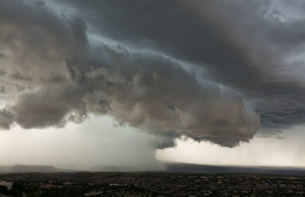
Cumulonimbus Clouds
The kings of clouds and the bringers of thunderstorms. Cumulonimbus clouds are massive and tower into the stratosphere. They’re responsible for lightning, thunder, hail, and heavy rain.

Deciphering Weather Patterns
Contrary to popular belief, clouds can appear in shades of pink, orange, and even purple during sunrise and sunset due to the scattering of sunlight.
The sky isn’t just a random canvas; it’s an intricate puzzle of weather patterns waiting to be decoded. Here’s how cloud formations give us clues about what’s on the meteorological menu:
Morning Cirrus
If you spot cirrus clouds in the morning, it’s often a sign that the weather will deteriorate later in the day. Those wispy clouds are like early warnings of an approaching storm.
Puffy Cumulus
Clear blue skies with fluffy cumulus clouds are a recipe for a pleasant day. But if those cumulus clouds start building vertically, beware – a thunderstorm might be brewing.
Lenticular Clouds
These unique lens-shaped clouds often form near mountains. If you see lenticular clouds, it’s a good indication that strong winds and turbulence are in the vicinity.

The next time you cast your gaze skyward, remember that the clouds aren’t just there to decorate the heavens. They are the storytellers of weather, the harbingers of storms, and the architects of our skies. With a keen eye and a bit of knowledge, you can unlock the secrets they hold and predict the atmospheric drama about to unfold.
So, keep your head in the clouds and your feet on the ground, and let the wonder of cloud formations guide you through the ever-changing sky.